A crack runs through a roadway. A headline above the City of Rancho Palos Verdes logo says Land Movement Update.

Updates 11-15-23

November 14 City Council Meeting

At last night’s meeting, the City Council voted to extend both the local emergency declaration and the building moratorium that were put in place on October 3 to bolster the City’s response to accelerated movement in the landslide complex. Both require renewal to stay in effect long-term.

The moratorium on new construction in the landslide complex has been approved by the California Department of Housing and Community Development and is now enforceable. It will be in place through October 2, 2024. The maximum the moratorium could be in effect if it were to be extended multiple times would be two years.

The local emergency declaration goes up for renewal every 60 days, so it is now in place through January 13, 2024. Because the first meeting in 2024 is likely to be canceled, the Council will consider extending it at the final City Council meeting of 2023 on December 19. Meeting information will be shared in a future update.

Last night’s discussion included a presentation from the City’s geologist on historical and recent activity in the landslide complex. City Staff also gave updates on short-term mitigation measures, including dewatering wells, filling fissures, Cal Water’s installation of temporary, above-ground water pipes in a portion of Seaview, and other infrastructure repairs and upgrades.

Watch a recording of the discussion on the City website.

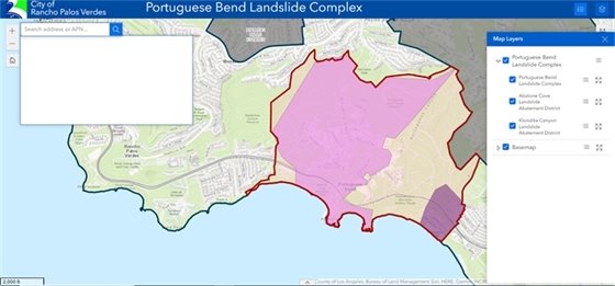
In addition to extending the local emergency declaration and the building moratorium, the Council directed the City Manager to send a letter to the Klondike Canyon Landslide Abatement District (KCLAD) stressing the importance to expedite mitigation measures and voted to send a follow-up letter to the California State Controller’s Office regarding KCLAD to help expedite response efforts.

GIS map

New GIS Map 

The City has created new interactive geographic information system (GIS) map with the boundaries of the Portuguese Bend Landslide Complex, the Abalone Cove Landside Abatement District (ACLAD), and the Klondike Canyon Landslide Abatement District (KCLAD).

To view the map, visit: rpvca.gov/landslidemap

When viewing the map, click on the Map Layers icon in the upper right-hand corner, then click on the triangle symbol next to the Portuguese Bend Landslide Complex layer to expand a dropdown menu with additional layers for the ACLAD and KCLAD.

Enter an address in the search bar in the upper left-hand corner of the map to see if it falls within the boundaries of the landslide complex, the ACLAD, or KCLAD.

Please note that you may be erroneously prompted to log in to view the map. If this happens, simply refresh the browser page and the prompt should go away. Our GIS vendor is working to resolve this issue.

Sandbags Available

Sandbags Available

Need sandbags to protect your property against runoff?
 
The City provides empty sandbags and sand for RPV residents to fill and make as needed.
 
Unfilled sandbags are located at the City Hall info desk and are available during regular business hours (7:30 a.m.-5:30 p.m. Monday-Thursday, and 7:30 a.m.-4:30 p.m. Friday). There is a limit of 10 sandbags per household with valid ID or proof of residency. Fill sand is located at City Hall in a designated area for residents to use. Please bring your shovels and tools as they are not provided.
 
If you need additional bags, they can be purchased at local hardware stores. For sandbag placement tips, please visit: ow.ly/yh0O50H9HuC

Share on Facebook
Share on Twitter
Share via Email

Copyright 2023 Rancho Palos Verdes. All Rights Reserved.
30940 Hawthorne Blvd, Rancho Palos Verdes, CA 90275

Powered by
CivicSend - A product of CivicPlus